

AIRS Profile Assimilation Background
The SPoRT center uses satellite-based observations to improve short-term weather forecasts. Observations from hyperspectral sounders like NASA's Atmospheric Infrared Sounder (AIRS), aboard the EOS polar-orbiting Aqua satellite, and EUMETSAT's Infrared Atmospheric Sounder Interferometer (IASI), aboard the polar-orbiting METOP satellite, provide near-radiosonde-quality atmospheric temperature profiles with the ability to resolve some small-scale vertical features in both clear and partly cloudy scenes.
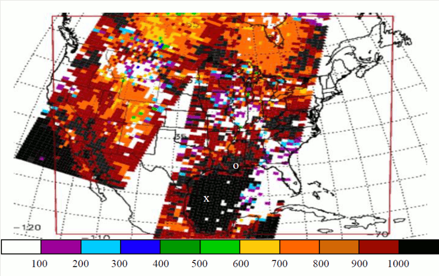
Figure 1. Pbest value for AIRS retrieved profiles assimilated at 0900 UTC on 13 February 2007. The color scale indicates the threshold pressure level denoting the highest-quality data in each profile. The red rectangle denotes the bounds of the WRF model domain. The "X" denotes the location of the Gulf of Mexico sounding and the "O" denotes the location of the Slidell, LA sounding shown in Fig. 3.
SPoRT has been assimilating AIRS profiles into the Weather Research and Forecasting (WRF) modeling since 2004. The evolution of the work and some lessons learned can be seen in Chou et al. (2006) and Zavodsky et al. (2007). The most recent completed projects use the 3-dimensional variational analysis system, WRF-Var. Two key lessons learned from previous work have been applied for use in the WRF-Var system: 1) effectively use the quality indicators to select only the highest quality observations and 2) assimilate the over-land and over-water soundings separately with different error characteristics to take into account emissivity issues that lead to degraded soundings over-land. Figure 1 shows an example of the 3-dimensional nature of assimilated data. SPoRT uses the latest version of JPL's AIRS retrieval algorithm (version 5) for this work. An overview of these profiles can be found at the AIRS Profile Background page. To separate the AIRS profiles into over-land and over-water soundings, changes to the WRF-Var source code were made to add AIRS-Water and AIRS-Land data set with observation errors based on estimates cited in Tobin et al. (2006) for over-land soundings and instrument specifications over water.
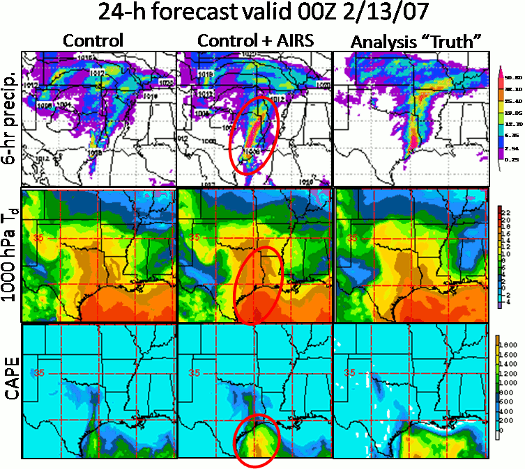
Figure 2. Comparison between control (no AIRS), AIRS, and "truth" for 6-hr precipitation (top row), 1000 hPa dew point (°C; middle row), and CAPE (J/kg; bottom row) for the 24-hour forecast initialized at 00Z on 12 February 2007 and valid at 13 Feburary 2007 showing improved forecasts with the assimilation of AIRS profile data.
Besides the observations and background field, one of the major components in the WRF-Var system is the background error covariance matrix (B matrix). Correct use of the B matrix is important in determining the appropriate weighting between the background field and observations as well as how information contained in observations is spread horizontally and vertically. Optimal analysis configuration desires background errors that are consistent with the domain/grid spacing, the model used as the background, and the season. A B matrix was calculated using the National Meterological Center (NMC) method (Parrish and Derber 1992), which takes differences between multiple 12- and 24-hour forecasts to determine model error. Within the WRF-Var system, the B matrix is generated using the "gen_be" program. In our application, short-term WRF forecasts for a 37-day case study period were used to run the NMC method. For more information on the B matrix used for this work, see Chou et al. (2008; PDF).
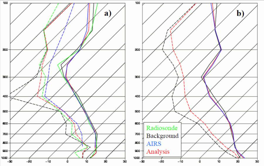
Figure 3. Temperature (solid) and dew point (dashed) profiles near a) Slidell, LA and b) a representative Gulf of Mexico sounding (24°N; 94°W) for the 0900 UTC 12 February 2007 analysis. The background (black) and WRF-Var analysis (red) profiles are for the nearest grid point. The AIRS retrieved profile (blue) is for the retrieval closest to the grid point. The radiosonde (green) is a linear interpolation to the analysis time.
For this research, the WRF forecast domain covers the contiguous United States, western Atlantic Ocean, and Gulf of Mexico. Each WRF forecast is initialized from a cold start using the 40-km North American Mesoscale (NAM) analysis at 0000 UTC, and its boundary conditions are updated every 3 hours using the NAM forecasts. The forecast/assimilation cycle runs several hours until the AIRS overpass time is reached (usually around 07-09Z for the morning pass). The WRF forecast is then used as the background field for the WRF-Var analysis wherein the AIRS profiles are assimilated. The forecast continues with the AIRS-enhanced WRF-Var analysis as the new initial state for a total forecast up to 48 hours. Results from this research use model forecasts run for a 37-day case study period from 17 January to 22 February 2007 and are presented in Zavodsky et al. (2011).
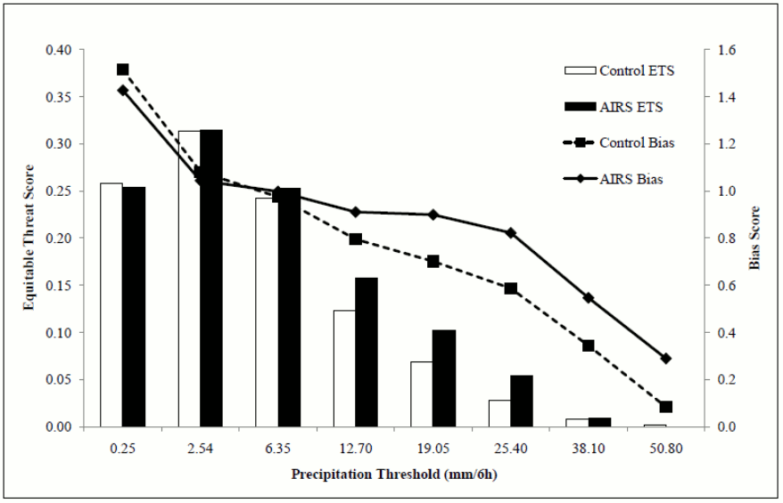
Figure 4. Six-hourly accumulated precipitation statistics for the 37-day case study period combining all 6-hourly forecasts from 18 to 48 hours. The bars represent equitable threat scores (left axis) and the lines represent bias scores (right axis). White bar and dashed line are for the CNTL runs; black bar and solid line are for the AIRS runs.
In that study, a severe weather case over the Gulf of Mexico coastal region was examined. For this event, the assimilation of AIRS profile data enhances a convective squall line across eastern Texas that appears in the verifying Stage IV precipitation analysis from NCEP that does not appear in the control (i.e., no AIRS) forecast (Figure 2). The reason for the enhanced convection was due to the assimilation of high-quality AIRS profile data over the Gulf of Mexico leading to decreased stability and higher lower-level moisture that was advected over the Gulf Coast. This instability and increased moisture can be seen in both the convective available potential energy (CAPE) and dew point temperature fields in Figure 2 and in the comparison soundings in Figure 3. Note that in the comparison soundings that the AIRS analysis is closer to a collocated rawinsonde observation than the background. An analysis closer to in situ observations than the background field should result in improved initial conditions and better forecasts when used to initialize a model forecast.
Additionally, precipitation forecasts were verified using NCEP Stage IV precipitation analyses and yield improved equitable threat and bias scores of 6-hr cumulative precipitation at most forecast hours at most precipitation thresholds. Figure 4 shows the combined precipitation forecast verification statistics, in which the equitable threat score (bars) is improved at all thresholds and bias scores (lines) are improved at most thresholds with the largest improvements for heavy precipitation cases.
References Cited
- Zavodsky, B.T., S.-H. Chou, and G.J. Jedlovec, 2011: Improved Regional Analyses and Heavy Precipitation Forecasts with Assimilation of Atmospheric Infrared Sounder Retrieved Thermodynamic Profiles. IEEE Trans. Geoscience and Remote Sensing, in review. (no link available at this time)
- Chou, S.-H., B. Zavodsky, G. Jedlovec, and W. Lapenta, 2008: Assimilation of Atmospheric InfraRed Sounder (AIRS) Profiles using WRF-Var. Preprints, 9th Annual WRF Users' Workshop, Boulder, CO, NCAR. P5.14. (available online)
- Chou, S.-H., B. Zavodsky, G.J. Jedlovec, and W. Lapenta, 2006: Assimilation of Atmospheric Infrared Sounder (AIRS) Data in a Regional Model. Preprints, 14th Conference on Satellite Meteorology and Oceanography, Atlanta, GA, AMS. P5.12. (abstract online)
- Parrish, D.F., and J.C. Derber, 1992: The National Meteorological Center's Spectral Statistical-Interpolation Analysis System. Monthly Weather Review, 120 (8), 1747-1763. (abstract online)
- Tobin, D.C., H.E. Revercomb, R.O. Knuteson, B.M. Lesht, L.L. Strow, S.E. Hannon, W.F. Feltz, L.A. Moy, E.J. Fetzer, and T.S. Cress, 2006: Atmospheric Radiation Measurement site atmospheric state best estimates for Atmospheric Infrared Sounder temperature and water vapor retrieval validation, J. Geophys. Res., 111, D09S14, doi:10.1029/2005JD006103. (abstract online)
- Zavodsky, B.T., S.-H. Chou, G. Jedlovec, and W. Lapenta, 2007: The Impact of Atmospheric Infrared Sounder (AIRS) Profiles on Short-term Weather Forecasts. SPIE Conf. on Algorithms and Technologies for Multispectral, Hyperspectral, and Ultraspectral Imagery XII, International Defense and Security Symp., Orlando, FL, SPIE. 6565-53. (abstract online)