

Real-Time Land Information System
SPoRT has developed a real-time configuration of the NASA Land Information System (LIS; Kumar et al. 2006, 2007) that runs over much of the central and eastern United States at 3-km grid spacing, with a 3-km resolution nested grid centered on Alabama. The real-time LIS has been running since Summer 2010 to support local modeling, as well as provide forecast offices with experimental land surface fields that can aid short-term forecasting and situational awareness. Recent versions of the Weather Research and Forecasting (WRF) Environmental Modeling System (EMS; Rozumalski 2007) contain an option to use LIS data for initializing land surface variables in local model runs. The LIS/Noah output are part of the SPoRT Local Data Manager data stream such that partner offices can acquire the data and display them in their decision support system.
The real-time LIS consists of a continuous integration of the Noah land surface model, which is same land surface model used in the operational National Centers for Environmental Prediction (NCEP) North American Mesoscale model. Prior to real-time implementation, the LIS/Noah run was initialized with a uniform first-guess soil moisture and soil temperature, and integrated in an offline mode for several years. In an offline mode, the land surface model is run apart from a numerical weather prediction model, with input variables (i.e. forcing) provided by atmospheric analyses. In this instance, a long-term "spin-up" integration of LIS/Noah is driven by input forcing from the NCEP Global Data Assimilation System (GDAS; Derber et al. 1991) analyses, North American Land Data Assimilation System (NLDAS; Cosgrove et al. 2003a, b) analyses, and hourly precipitation estimates from the NCEP Stage IV product (Lin and Mitchell 2005; Lin et al. 2005). The several-year integration is required to remove any memory of the first-guess initialization and ensure that the soil variables have reached an equilibrium state with the atmospheric input forcing. Starting in Summer 2010, this long-term LIS/Noah integration has been continually re-started every 6 hours in a real-time capacity to provide (1) land surface initialization variables at high resolution for local numerical weather prediction models, and (2) high-resolution depictions of the land surface that can aid short-term forecasting and situational awareness at NWS weather forecast offices.
To ensure data availability in real time applications, short-term forecasts up to 15 hours from the NCEP Global Forecast System (GFS) model are used in each 6-hourly LIS/Noah cycle, thus providing a small forecast component to the real-time LIS. Output forced by the GFS forecasts is over-written in subsequent cycles as atmospheric analyses become available, ensuring a realistic land surface solution based on analyses. Output is written into gridded binary (GRIB) format, thus enabling an easy incorporation into the WRF EMS and display in AWIPS/AWIPS II. Beginning in April 2011, the real-time LIS began ingesting SPoRT's daily 1-km resolution MODIS Greenness Vegetation Fraction (GVF) data (Case et al. 2011a) in place of the 0.144° resolution NCEP GVF climatology for improved representation of vegetation coverage in the LIS/Noah integration. Figure 1 shows the geographical coverage of the regional and Alabama-centric 3-km domains.
|
|
|
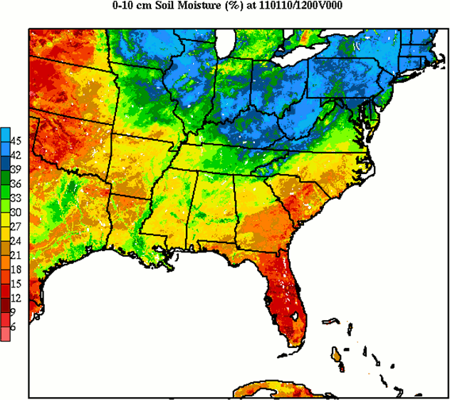
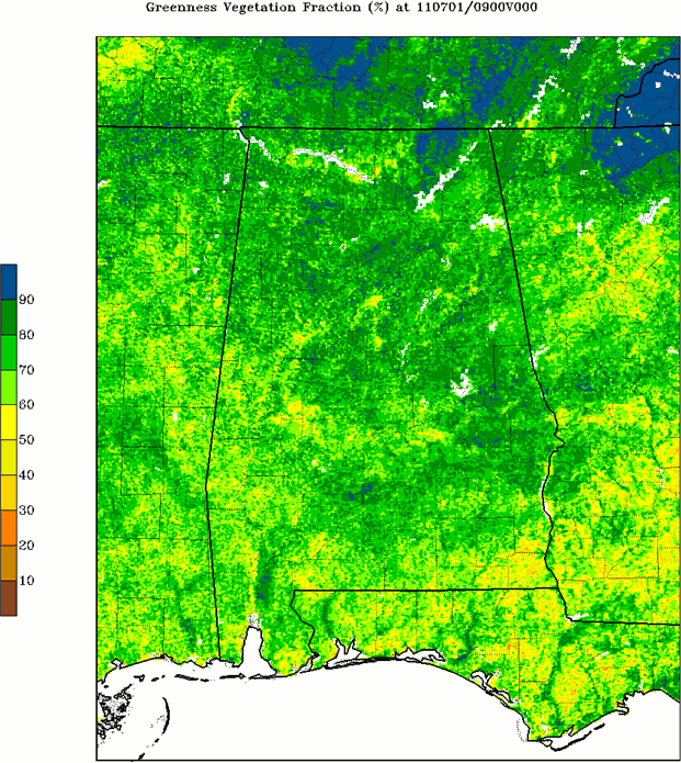
Figure 1. Plot of 0-10 cm soil moisture over the central/eastern U.S. 3-km domain (left), and MODIS Greenness Vegetation Fraction (GVF) over the Alabama 3-km domain (right).
|
|
Application: LIS fields for Initializing Local Model Runs
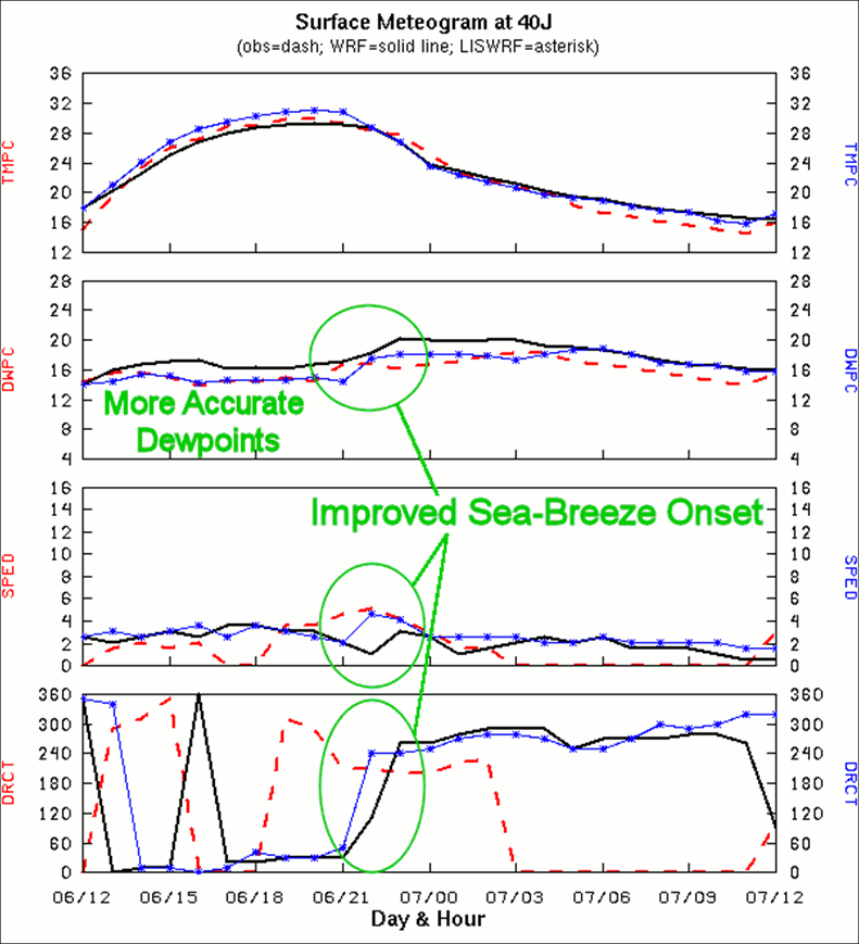
Figure 2. A meteogram plot at Perry, FL (40J) of temperature (°C), dewpoint (°C), wind speed (m/s-1), and wind direction (degrees from 1200 UTC 6 May to 1200 UTC 7 May 2004). The graphs compare hourly WRF forecasts interpolated to the station location from the Control simulation (solid bold line) and LISWRF run (solid line with labels) to observations (dashed line).
Modeling studies by SPoRT have demonstrated the positive impacts of applying the NASA LIS to initialize land surface variables in regional high-resolution NWP model simulations. SPoRT conducted a month-long assessment of daily simulations over Florida using the WRF model initialized with high-resolution land surface data from the LIS versus a Control configuration that used land surface data interpolated from the NCEP Eta model. In Case et al. (2008), comparisons between the Control and LIS-initialized WRF runs suggested that the LIS data led to an improvement in the timing and evolution of a sea-breeze circulation over portions of northwestern Florida from 6 May 2004 (Figure 2). Surface verification statistics during the whole month of May 2004 indicated that the LIS-initialized WRF runs produced a more accurate diurnal range in 2-m temperatures compared to the Control runs through a reduction in the nocturnal warm bias combined with a reduction in the daytime cold bias. The positive results of these experiments over Florida illustrated the importance of initializing regional NWP models with high-resolution, representative land surface data.
A follow-on study focused on the impacts of LIS land surface and SPoRT's MODIS-only sea surface temperatures (Haines et al. 2007) on daily WRF explicit precipitation forecasts over the southeastern U.S. for a 3-month period from June to August 2008 (Case et al. 2011b). One of the most challenging weather forecast problems in the southeastern U.S. is daily summertime pulse-type convection. For this study, it was hypothesized that high-resolution, consistent representations of surface properties such as soil moisture, soil temperature, and sea surface temperature (SST) are necessary to better simulate the interactions between the surface and atmosphere, and ultimately improve predictions of local circulations and summertime pulse-type convection. This study used both LIS land surface fields and SPoRT's MODIS SSTs, thereby providing a high-quality, high-resolution lower boundary initial condition over the entire modeling domain. SPoRT made use of traditional calculations as well as an object-based matching tool known as the Method for Object-based Diagnostic Evaluation (MODE; Brown et al. 2007; Davis et al. 2009) to obtain precipitation verification statistics during summer 2008.
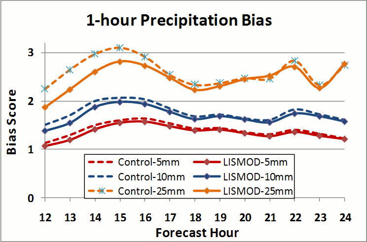
Figure 3. Bias of 1-hour accumulated precipitation during the peak convective hours of 1500 UTC to 0300 UTC (forecast hours 12-24) for all 81 forecasts in the study period (June to August 2008).
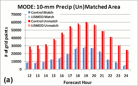
Results indicated that the LIS+MODIS initialized WRF runs (LISMOD) exhibited a modest improvement in forecast precipitation over Control simulations initialized with land and sea surface information interpolated from the 12-km North American Mesoscale model. The one-hour accumulated precipitation bias during the peak convective hours was improved in the LISMOD runs (Figure 3). The object matching technique within MODE relaxed the stringent grid point-by-grid point criterion placed on precipitation verification when using traditional threat score approaches. Precipitation objects were identified in both WRF forecast and gridded Stage IV precipitation analyses and matched to one another (i.e. "hit"). Select one-hour accumulation thresholds were applied to each field, and objects were matched based on a variety of spatial characteristics, the most important being an 80-km distance requirement. Only forecast/observed precipitation objects within 80 km of each other were considered for possible matching.
A summary of the mean matched/unmatched precipitation object areas per forecast run is provided in Table 1 for each of the three accumulated precipitation thresholds examined (5, 10, and 25 mm per hour). The LISMOD produced on average more matched and fewer unmatched object areas compared to the Control for all three thresholds between forecast hours 12-24. The lone exception is the matched area for 25 mm (1 h)-1, in which the matched area averaged the same in both the Control and LISMOD. All of the improvements in unmatched area were statistically significant at the 99th percentile, whereas only the 4.3% improvement in 10 mm (1 h)-1 matched area was marginally significant at the 90th percentile.
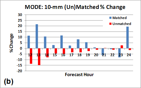
The improvements to the forecast precipitation were also prevalent as a function of forecast hour, at least in the 10 mm (1 h)-1 threshold (Figure 4). During the peak convective times, the LISMOD consistently produced a slight increase in the matched area and a slight decrease in the unmatched area as a function of forecast hour (Figure 4a). The percentage change in matched/unmatched area indicated the greatest improvement earlier in the day between forecast hours 12 and 19 (Figure 4b). The 5-mm (1 h)-1 also showed a notable improvement in the LISMOD, mainly from a reduction in unmatched area (not shown). However, the 25-mm (1 h)-1 threshold did not show much of a clear distinction between the Control and LISMOD as a function of forecast hour.
|
Table 1. Mean matched and unmatched 1-hour precipitation object areas for the Control and LISMOD per forecast run, and the percent improvement in LISMOD over the Control by accumulation interval. All 1-h forecasts during the peak convective hours are combined for each forecast run (12-24 h, corresponding to the 1500-0300 UTC window). Differences and % Change in bold font indicate statistical significance at the 99th percentile while italics font indicates significance at the 90th percentile. |
||||
|
Quantity (mean # grid points per model run) |
Control |
LISMOD |
Difference (LISMOD - Control) |
Change |
|
5-mm Matched |
11 911 |
12 045 |
134 |
1.1% |
|
5-mm Unmatched |
17 750 |
17 175 |
-575 |
-3.2% |
|
10-mm Matched |
2 456 |
2 562 |
106 |
4.3% |
|
10-mm Unmatched |
6 798 |
6 538 |
-260 |
3.8% |
|
25-mm Matched |
60 |
60 |
0 |
0% |
|
25-mm Unmatched |
549 |
505 |
-44 |
-8.0% |
|
|
|
Figure 4. Comparison between the total matched and unmatched object areas from all 81 forecast cycles for 1-h accumulated precipitation >= 10 mm during the forecast hours from the diurnal peak convective activity (12-24 hours, valid 1500 UTC to 0300 UTC). (a) Total matched object area (blue bars) and unmatched object area (red bars) for the Control (solid bars) and LISMOD (hatched bars), and (b) LISMOD percentage change from the Control matched/unmatched object area.
|
|
Application: LIS Fields for Diagnosing Convection Initiation
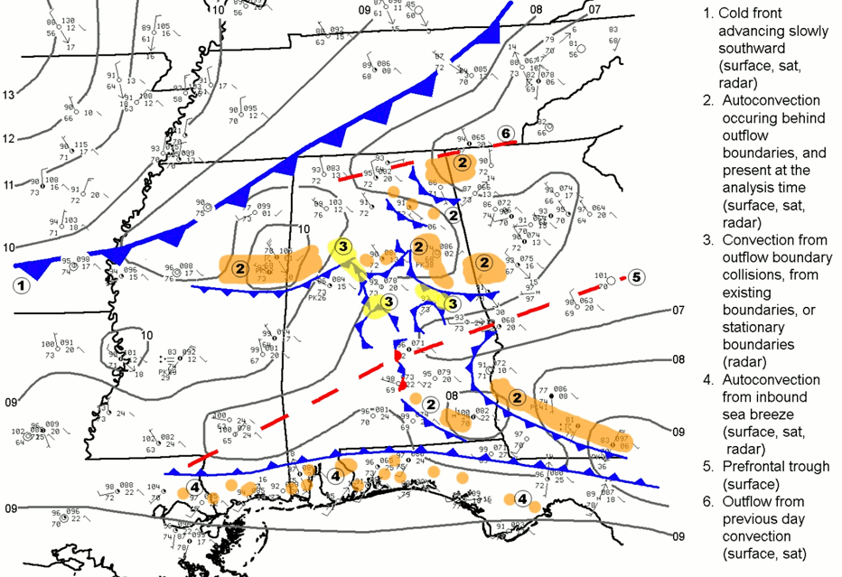
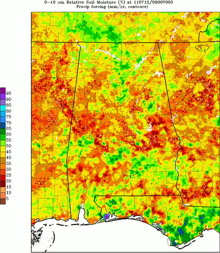
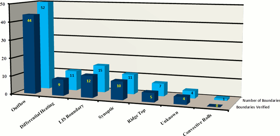
The NWS Birmingham, AL weather forecast office generated experimental convection initiation forecasts during the Summer 2010 followed by experimental enhanced probability of precipitation products in the Summer 2011. These experimental products were largely based on techniques developed in-house to identify pre-existing convergent boundaries that would favor convection initiation during the weakly-forced summer months when diurnal convective development is typically less predictable (Goggins et al. 2010). A sample complex surface analysis of boundaries on a given day is shown in Figure 5 while an example LIS 0-10 cm relative soil moisture fields is given in Figure 6.
The NWS Birmingham office began incorporating real-time LIS fields into their daily summertime convection initiation forecasts in Summer 2010 to provide more clarity in the origins of boundaries and to offer information to diagnose regions favoring differential heating boundaries caused by gradients in soil moisture and/or surface sensible and latent heat fluxes. The incorporation of daily real-time LIS output into the boundary identification technique enabled the NWS Birmingham office to reduce the number of boundaries of unknown origin and further clarify the forecaster's situational awareness on a given day (Figure 7 and Figure 8). The real-time LIS output fields on the 3-km Alabama domain are available via the LIS real-time SPoRT pags (AL data, SE US data). Subsequent efforts enabled the LIS data to be displayed within the Advanced Weather Interactive Processing System through instructions developed by the NWS Huntsville, AL.
|
|
|
Figure 5. Sample surface hand analysis produced by the NWS Birmingham forecasters when identifying convergent boundaries conducive to convection initiation during the summer months.
|
Figure 6. Sample LIS 0-10 cm relative soil moisture plot from 12 July 2011, used to aid in diagnosing differential heating zones associated with land surface discontinuities. Notice the corridor of drier soils in central Alabama, interspersed with local pockets of much more moist soils.
|
|
|
|
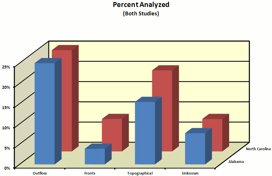
Figure 7. Categorization of boundary origin types in central Alabama during the 2009 summer.
|
Figure 8. Categorization of boundary origin types in central Alabama during the 2010 summer. Note the reduction of "unknown" boundaries compared to 2009, and the presence of a significant number of LIS-associated boundaries that verified with the occurrence of convection initiation.
|
Link to the Land Information System Web Page:
http://lis.gsfc.nasa.gov/
References Cited
- Brown, B. G., R. Bullock, J. Halley Gotway, D. Ahijevych, C. Davis, E. Gilleland, and L. Holland, 2007: Application of the MODE object-based verification tool for the evaluation of model precipitation fields. Preprints, 22nd Conf. on Weather Analysis and Forecasting and 18th Conf. on Numerical Weather Prediction, Park City, UT, Amer. Meteor. Soc., 10A.2. [available online]
- Case, J. L., W. L. Crosson, S. V. Kumar, W. M. Lapenta, and C. D. Peters-Lidard, 2008: Impacts of High-Resolution Land Surface Initialization on Regional Sensible Weather Forecasts from the WRF Model. J. Hydrometeor., 9, 1249-1266.
- Case, J. L., F. J. LaFontaine, S. V. Kumar, and G. J. Jedlovec, 2011a: A real-time MODIS vegetation composite for land surface models and short-term forecasting. Preprints, 15th Symp. on Integrated Observing and Assimilation Systems for the Atmosphere, Oceans and Land Surface, Seattle, WA, Amer. Meteor. Soc., 11.2. [available online]
- Case, J. L., S. V. Kumar, J. Srikishen, and G. J. Jedlovec, 2011b: Improving Numerical Weather Predictions of Summertime Precipitation over the Southeastern United States through a High-Resolution Initialization of the Surface State. Wea. Forecasting, 26, 785-807.
- Cosgrove, B. A., and Coauthors, 2003a: Real-time and retrospective forcing in the North American Land Data Assimilation System (NLDAS) project. J. Geophys. Res., 108(D22), 8842, doi:10.1029/2002JD003118, 2003.
- Cosgrove, B. A., and Coauthors, 2003b: Land surface model spin-up behavior in the North American Land Data Assimilation System (NLDAS). J. Geophys. Res., 108(D22), 8845, doi:10.1029/2002JD003316.
- Davis, C. A., B. G. Brown, R. Bullock, and J. Halley-Gotway, 2009: The Method for Object-based Diagnostic Evaluation (MODE) applied to numerical forecasts from the 2005 NSSL/SPC Spring Program. Wea. Forecasting, 24, 1252-1267.
- Derber, J. C., D. F. Parrish, and S. J. Lord, 1991: The new global operational analysis system at the National Meteorological Center. Wea. Forecasting, 6, 538-547.
- Goggins, G. D., M. L. Grantham, S. W. Unger, K. B. Laws, K. J. Pence, and L. Dawson, 2010: Analysis of summer convection over central Alabama. Preprints, 15th Symp. on Meteorological Observation and Instrumentation. Atlanta, GA, Amer. Meteor. Soc., 9.2. [available online]
- Haines, S. L., G. J. Jedlovec, and S. M. Lazarus, 2007: A MODIS sea surface temperature composite for regional applications. IEEE Trans. Geosci. Remote Sens., 45, 2919-2927.
- Kumar, S. V., and Coauthors, 2006. Land Information System - An Interoperable Framework for High Resolution Land Surface Modeling. Environmental Modeling & Software, 21 (10), 1402-1415, doi:10.1016/j.envsoft.2005.07.004.
- Kumar, S. V., C. D. Peters-Lidard, J. L. Eastman, and W.-K. Tao, 2007: An integrated high-resolution hydrometeorological modeling testbed using LIS and WRF. Environmental Modeling & Software, 23 (2), 169-181, doi: 10.1016/j.envsoft.2007.05.012.
- Lin, Y., and K. E. Mitchell, 2005: The NCEP Stage II/IV hourly precipitation analyses: Development and applications. Preprints, 19th Conf. on Hydrology, San Diego, CA, Amer. Meteor. Soc., 1.2. [available online]
- Lin, Y., K. E. Mitchell, E. Rogers, and G. J. DiMego, 2005: Using hourly and daily precipitation analyses to improve model water budget. Preprints, Ninth Symp. on Integrated Observing and Assimilation Systems for the Atmosphere, Oceans, and Land Surface, San Diego, CA, Amer. Meteor. Soc., 3.3. [available online]
- Rozumalski, R. A., 2007: WRF Environmental Modeling System User's Guide: Demystifying the process of installing, configuring, and running the Weather Research and Forecasting model, NOAA/NWS Forecast Decision Training Branch, COMET/UCAR, 95 pp. [available online]