Technical Contact: Dr. Emily Berndt (emily.b.berndt@nasa.gov)
Responsible Official: Dr. Gary Jedlovec (gary.jedlovec@nasa.gov)
Page Curator: Paul Meyer (paul.meyer@nasa.gov)
Disclaimer
The SPoRT program transitions unique NASA satellite data and research capabilities to the operational weather community to improve short-term weather forecasts on a regional and local scale. NASA established the project in 2001, drawing on real-time MODIS, AIRS, and AMSR-E data from direct broadcast ground stations to address forecast problems common to WFOs in the southeast U.S. SPoRT currently works with a number of WFOs on problems such as the timing and location of severe weather, diagnosing weather conditions influenced by terrain and other local features, reduced surface visibility due to smoke, fog, and low clouds, predicting weather variations due to land / sea breeze circulations, and monitoring conditions in data void regions. SPoRT involves forecasters in the entire process — matching forecast problems to data and research capabilities, testing solutions in a quasi-operational environment, and then transitioning proven solutions into the forecaster's decision support system. SPoRT also develops new product training and involves forecasters in the assessment of the utility of the NASA data on the relevant forecast problems. Additional information on SPoRT may be found in (Jedlovec 2013; SPoRT 2015) and on the web at the SPoRT Website.
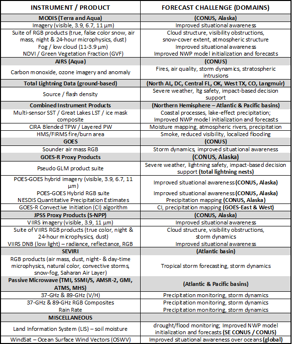
A suite of over 40 products is currently provided to 30 NWS WFOs (in all 6 NWS regions) and 5 NCEP National Centers to assist with nowcasting and short-term forecast problems. Real-time high resolution MODIS and VIIRS multispectral (RGB) imagery products have been successfully used to improve situational awareness for a variety of nowcasting applications. A notable impact on hydrologic forecasting in the upper plains states has been documented by Loss et al. (2009); dust imagery has been used by forecasters in the southwest U.S. (Fuell et al. 2016 in press). Forecasters in Alaska regularly use RGB imagery as part of their forecast process (Fuell et al. 2016). Atmospheric profiles from the AIRS in data void regions have been assimilated into weather forecast models and shown to improve the initial conditions and subsequent forecasts of sensible weather elements with the WRF model (Zavodsky et al. 2012). Continued development of capabilities for integrating datasets into the Gridpoint Statistical Interpolation (GSI) data assimilation system are being pursued (Berndt et al. 2015; Li et al. 2016) SPoRT scientists work collaboratively on forecast problems and product transitions to bring NASA assets into the WRF Environmental Modeling System (EMS, Rozumalski 2007). A high resolution enhanced MODIS composite product (Schiferl et al. 2010; Haines et al. 2007) is the default option in the WRF EMS used by many WFOs and the external modeling community. Near real-time runs of the NASA Land Information System (LIS) (Case et al. 2008) as implemented by Case et al. (2010) are also linked with the WRF to provide improved initial conditions for model forecasts and brought into AWIPS for nowcasting applications (e.g., Case et al. 2016). Assimilation of soil moisture observations from SMOS and SMAP (e.g., Blankenship 2016) through LIS are anticipated to provide improvements to soil moisture products. Total lightning measurements from ground based networks have been used to provide additional lead time in severe weather warnings issued by Southern Region WFOs. SPoRT will extend its transition activities to include new satellite observations integrated into new decision support systems in additional weather service offices over the next few years. Data from the VIIRS instrument on the Suomi National Polar-orbiting Partnership (SNPP) is already providing follow-on capabilities to those of the NASA MODIS and AIRS instruments. The existing and new data streams from JPSS and NASA Decadal Survey missions will be integrated in the NWS's AWIPS system to extend the use of unique high resolution data in the WFO environment. Expansion of these efforts to WFOs in other regions will enhance the utility of these special observing systems.
References Cited