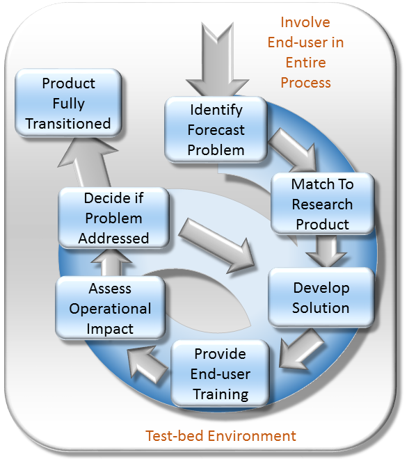
SPoRT's Role in the SWOT Early Adopter Program
Between May 26 and June 1, 2020, a virtual hackathon was hosted by the University of Washington for SWOT early adopters. SWOT, or Surface Water and Ocean Topography, is a joint mission between NASA’s JPL and the French space agency CNES, with contributions from Canada’s CSA and the UK Space Agency. The SWOT satellite observatory will survey surface and ocean water around the globe, collecting data with groundbreaking resolution. SWOT is the first satellite mission to ever survey water level on a global scale, and its data will have a major impact on a number of applications. Along with fifteen other groups, NASA SPoRT is a member of the SWOT Early Adopter Program; these early adopters are preparing to integrate SWOT data into their projects. When the SWOT satellite observatory is launched by a SpaceX Falcon 9 rocket in 2022 and begins collecting data, SWOT early adopters will be prepared to use this data in a variety of applications. The SWOT Hackathon was designed to engage early adopters and help them overcome technical issues they may have experienced. SPoRT scientist Dr. Nicholas Elmer participated in the hackathon as a presenter and “hacker helper,” assisting early adopters in the use of the CNES SWOT hydrology data simulator.
The SWOT satellite observatory will carry a number of instruments to facilitate data collection. A JPL-developed Ka-Band Radar Interferometer, or KaRIn, will be the primary instrument used to collect water level data. KaRIn, which utilizes two antennas, will work by transmitting a signal from one antenna, and then receiving the same signal back with both antennas after it bounces off of the earth’s surface. The phase difference between these two signals will be used to calculate water level with extreme precision; over the ocean, SWOT’s data will be accurate down to about a centimeter, over an area of 125 km at any given time. SWOT will collect data in 21-day cycles, during which the entirety of the globe, excluding the poles, will be observed. The satellite observatory will also carry an altimeter, a DORIS antenna to receive signals from Earth, a radiometer to measure water vapor between SWOT and the surface, an X-band antenna for data downlink, and a GPS receiver.
As a SWOT early adopter, SPoRT is preparing to integrate SWOT data into the NOAA National Water Model and the SPoRT Land Information System (or LIS) product. For his PhD dissertation, Dr. Nicholas Elmer developed a method to assimilate SWOT data into the WRF-Hydro modeling system, which is the backbone of the NOAA National Water Model. As a SPoRT scientist, Dr. Elmer is taking the next step to include SWOT data in the SPoRT LIS product. Dr. Elmer plays a key role in the SWOT early adopter process, as he contributed to the CNES-developed SWOT data simulator, which early adopters use to ensure their applications will function correctly with SWOT data. Dr. Elmer was one of the first early adopters to make use of the simulator, and wrote the tutorial used by early-adopters at the hackathon. During the hackathon, Dr. Elmer assisted international researchers who were working on integrating SWOT data into local hydrological models. Dr. Elmner also contributed code to the simulator that allowed it to create a time series of simulated SWOT data with varying water surface elevations, which CNES adopted into the official simulator distribution.
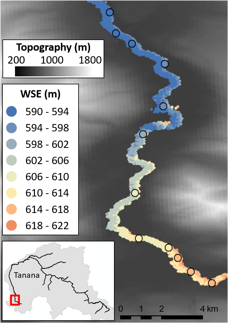
Example of CNES SWOT simulator pixel cloud (point-based water surface elevations; small circles, no outline) and spatially-averaged water surface elevations (large circles with black outline) along the Nenana River in Alaska. Figure adapted from Elmer et al. (2020).
Throughout the early adopter process, SPoRT has been providing valuable feedback to NASA and CNES. Due to its focus on research to operations and research to applications, SPoRT has provided a unique perspective, communicating the need for low-latency SWOT products for use in operational and near-real-time systems. When SWOT launches, it will bring major improvements to a wide array of applications; SWOT will vastly improve our understanding of Earth’s bodies of water, and will benefit forecasters, scientists, oceanographers, hydrologists, and many others. SWOT will also improve understanding of changing lake, reservoir, and river volumes, which will allow scientists to understand fresh water availability. SWOT’s observations of the ocean will improve scientists’ understanding of global climate change, pollution, and environment stability. SWOT is a major breakthrough in water observation, and SPoRT is playing a small but important role in its development.
References:
Elmer, N. J., C. R. Hain, F. Hossain, D. Desroches, C. Pottier (2020), Generating proxy SWOT water surface elevations using WRF-Hydro and the CNES SWOT Hydrology Simulator, Water Resources Research, American Geophysical Union, Early Online Release, https://doi.org/10.1002/essoar.10502399.1 .