


Experiments
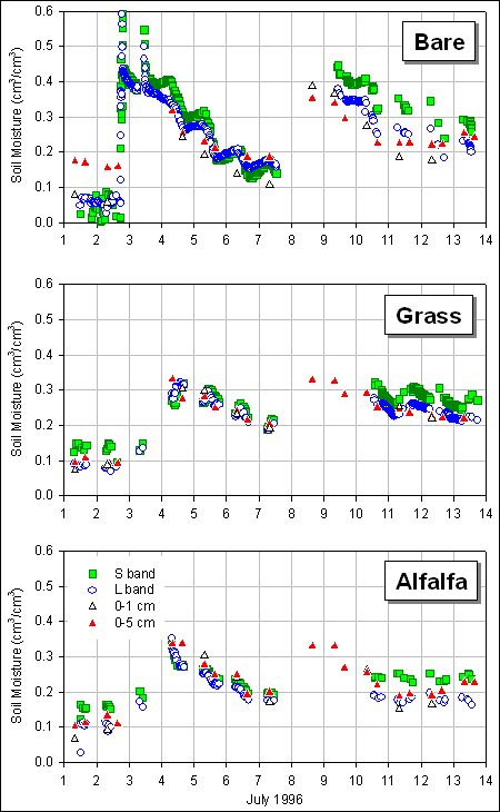
 Huntsville ‘96 and ‘98 were experiments in ground-based passive microwave remote sensing of soil moisture conducted in Huntsville, Alabama from July 1-14, 1996 and from June 16-27, 1998. The goals of these experiments were to evaluate the overall performance of an empirically based retrieval algorithm at L, S and C bands under different environmental conditions and to characterize the site-specific accuracy inherent within the technique. Through attempts to define the emitting depth at each wavelength and assess the accuracy of remotely sensed soil moisture estimates, numerous questions were raised as to the sensitivity of the soil dielectric mixing model (with its vegetation correction algorithm) to its various components. To some extent the remote sensing data also contain information about hydrologic processes (evaporation, infiltration rates, dew formation, etc.), but specific measurements required to verify hypotheses are limited. The data were also used in conjunction with a soil hydrology model to study whether estimates of profile soil moisture could be improved with frequent estimates of surface soil moisture derived from remote sensing.
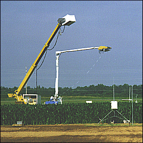
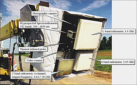
 The configuration of instruments during both experiments was nearly the same. The S (2.65 GHz) and L (1.413 GHz) band Microwave Radiometer (SLMR) is a dual-frequency passive sensor system. In addition, a six channel stepped-frequency (4.63, 5.06, 5.91, 6.34, 6.77, 7.20 GHz), single polarization C band radiometer was added to this system. All radiometers were mounted to observe horizontal polarization. A 4-channel Exotech radiometer was equipped with filters corresponding to Landsat Thematic Mapper bands 1, 2, 3, and 4. An Everest 4000A thermal infrared sensor with 7.5-15 mm bandpass obtained spot measurements of surface temperature. During Huntsville ’98, the Exotech radiometer was replaced with a GER1500 spectroradiometer with 512 bands. Also during Huntsville ’96, a thermal infrared imaging radiometer with an 8-12 mm bandpass was used to characterize the spatial variability of surface temperature in the SLMR footprints. This instrument was not available in 1998. A video camera was used for relocating the instruments over the same target on the ground after the truck was moved. The SLMR and ancillary sensors were mounted on a common frame that provided 270° of rotation in the vertical plane of the boom. Look angle, monitored by inclinometers inside the radiometer housing, was manipulated by a hand control at the data system. Instrument operation and data acquisition for the SLMR and ancillary instruments were controlled through a common data acquisition system that was located in a truck situated adjacent to the boom truck.
This research was conducted in collaboration with the Center for Hydrology, Soil Climatology and Remote Sensing at Alabama A&M University, NASA Goddard Space Flight Center, and the USDA-ARS Hydrology Lab in Beltsville, MD.
Acknowledgements:
This research was supported by NASA through grant no. NCCW-0084 to Alabama A&M University , Center for Hydrology, Soil Climatology and Remote Sensing. Investigators with Universities Space Research Association were supported by SUB95-164 from Alabama A&M University .
More information can be found in:
Laymon, C., Crosson, W., Jackson, T., Manu, A., and Tsegaye, T., 2001, Ground-based passive microwave remote sensing observations of soil moisture at S-band and L-band with insight into measurement accuracy, IEEE Trans. on Geosci. and Remote Sens., 39(9), 1844-1858.
Laymon, C.A., Belisle, W., Coleman, T., Crosson, W., Fahsi, A., Jackson, T., Manu, A., O’Neill, P., Senwo, Z., and Tsegaye, T., 1999, Huntsville ’96: An experiment in ground-based microwave remote sensing of soil moisture, International Jour. Remote Sens., 20(4), 823-828.