


Algorithms
Remote sensing of soil moisture is dependent on accurate estimation of microwave brightness temperatures. Processing of sensor observations using simplistic interpolation schemes can impose biases unrelated to instrument accuracy. We revisited this topic and developed a technique to deconvolve microwave brightness temperature observations to field mean values. The technique resulted in more realistic distribution of brightness temperatures than was provided by conventional data interpolation methods.
Typically, the instantaneous field of view (IFOV) of air or space borne sensors is significantly greater than the spacing between adjacent footprints, i.e. the target surface is over-sampled. Conventionally, observations of this type are averaged to produce smooth spatial data fields of brightness temperatures. However, the conventional approach has a tendency to contradict reality in which the brightness temperatures are strongly dependent on landcover, which is characterized by sharp boundaries. In an attempt to better understand the contrast in brightness temperatures for different landcover types, we developed a technique to take advantage of the microwave sensor over-sampling. Targets within the field of view of each remotely sensed observation contribute in a non-linear manner to the observation, as a function of the sensor antenna response function. The actual observation is convolution of responses from the targets (agricultural fields for example) underneath with roughly bell shaped (Gaussian) surface of the antenna response function centered at the spatial location of the observation. Knowing the shape of the surface and the spatial location of the observation, we can integrate the contribution of each of target field to each observation.
Because the surface is over sampled, each target field has several observations centered in it. Even though many of the same fields are in the field of view of subsequent observations, the difference is the varying contribution from each target field to each of the observation. In other words, we have multiple observations of the same fields, but with varying amount of contributions. Optimizing the solution of the system of equations generated by the each of the observations, we obtain the individual value of each of the fields. In other words, we optimally de-convolve (ODC) the sensor brightness temperature observations into contributing target-mean brightness temperatures.
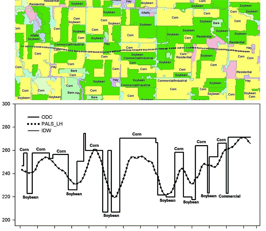 |
| Figure 1. Transect of PALS observations (L band, H-polarization), landcover, inverse distance weighted (IDW) interpolation and underlying field ODC brightness temperatures for July 7, 2002 . The IDW or other similar methods reproduces the observations and results in considerable smoothing whereas the ODC method estimates field values and reconstructs the sharp contrast between landcover types. Note that the IDW technique underestimates the maximum and minimum brightness temperature values. |
The optimal deconvolution approach produces better estimates of field or segment brightness temperatures as compared with a conventional interpolation technique (Inverse Distance Weighted interpolation (IDW)) (Figure 1). ODC-estimated brightness temperatures are shown to agree better with PALS pure observations (observations originating from a single agricultural field). ODC estimates are also shown to better match the dynamic range of brightness temperatures between corn and soybean fields, whereas interpolated brightness temperatures unrealistically dampened the transitions between contrasting fields (Figure 1 and 2). Such increased fidelity in estimation of brightness temperature may result in improved retrieved soil moisture.
 |
|
Figure 2. ODC field brightness temperature, inverse distance weighted (IDW) interpolated brightness temperatures averaged over each agricultural field, and IDW estimates on a 10 m grid for the SMEX02 watershed study area on July 7, 2002 . Yellow in the agricultural fields represent corn, whereas green represents soybeans. |
Further details can be found in this journal article.
Acknowledgements:
This research was supported by NASA (David Starr, Program Mgr) through grant no. 291-07-75-90 to Universities Space Research Association.