


Research
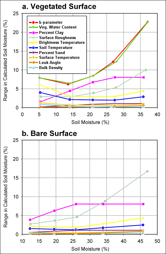 |
| Figure 1 : Graphs showing the range in soil moisture (%) calculated at different moisture levels by varying the input variable or parameter over the range of possible estimation errors. Calculations are made for vegetated (a.) and bare (b.) surfaces. |
Although errors in estimating most soil moisture algorithm parameters at regional scale yield total variations of less than about ± 2% volumetric water content (vwc), errors in estimating vegetation water content, vegetation b parameter, percent clay, and surface roughness yield much larger uncertainty in estimated soil moisture (Figure 1). The effects of these parameter variations on calculated soil moisture are greater for wetter soils (above 25% vwc) and can result in total errors in soil moisture retrieval of up to ± 12% vwc. Errors in estimating these same parameters have a compound effect on calculated soil moisture when they vary collectively, and may yield variations in soil moisture retrieval as high as 38% vwc (-12%, +26%) for wet soil. Even under drier conditions between 10% and 25% vwc, parameter errors result in soil moisture uncertainties of ± 4.5% to ± 7.5%. Such uncertainties are unacceptably high for many applications and may preclude using these data where individual pixel values are of interest.
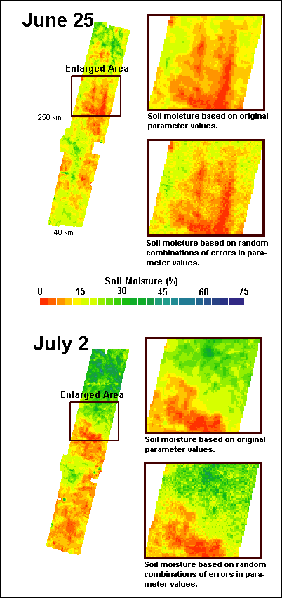 |
| Figure 2 : Remotely sensed distributed soil moisture on June 25 and July 2 during the Southern Great Plains 1997 Hydrology Experiment. The long strips represent the entire data set for each day, whereas the boxes show an enlarged area highlighting the differences in soil moisture fields calculated based on the original parameter values versus semi-random parameter values. |
In summary, errors in regional scale estimates of vegetation water content, the b parameter, percent clay and surface roughness may lead to very substantial errors in retrieved soil moisture. These errors are particularly high for wetter soils. Such errors may preclude using these data where individual pixel values are of interest. On a regional scale, however, where samples sizes are large, uncertainties in remotely sensed soil moisture are within acceptable limits for most disciplines.
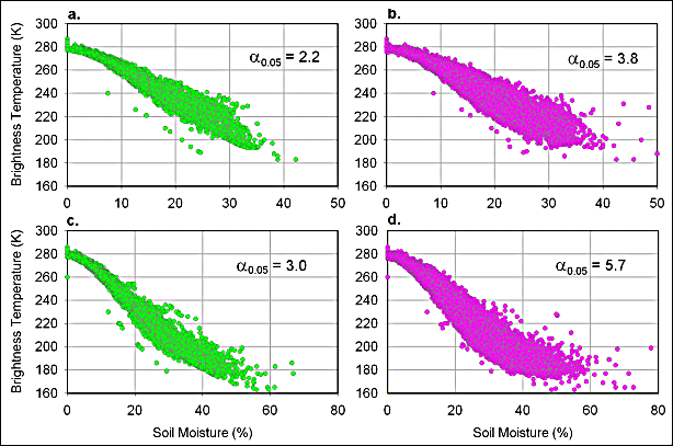 |
| Figure 3 : Scatterplots of soil moisture calculations for SGP97 for June 25 (a, b) and June 2 (c, d). The scatterplots on the left show soil moisture retrieval using the original input parameters, whereas the scatterplots on the right show recalculated soil moisture using random combinations of vegetation water content, percent clay, and surface roughness. The mean 95% confidence limit for the majority of the distribution is shown on each plot. |
Acknowledgements:
This research was supported by NASA through grant no. 291-07-75-90 to Universities Space Research Association and grant no. NCCW-0084 to Alabama A&M University, Center for Hydrology, Soil Climatology and Remote Sensing. This work was conducted in collaboration with Dr. Andrew Manu, Iowa State University and Dr. Frank Archer, Alabama A&M University.
Reference Cited:
Jackson, T.J., Le Vine, D. M., Hsu, A. Y., Oldak, A., Starks, P. J., Swift, C. T., Isham, J. D., and Haken, M., 1999, Soil moisture mapping at regional scales using microwave radiometry: the Southern Great Plains Hydrology Experiment. IEEE Trans. Geosci. Remote Sens., 37: 2136-2151.