Algorithms
Soil moisture information is of vital importance for many applications, most notably agriculture, water resource management and numerical weather prediction. In order to effectively utilize remote sensing data to estimate soil moisture both near the surface and at greater depths, it is necessary to assimilate the data into a modeling system. We have developed a measurement-modeling system incorporating remote microwave observations, a surface hydrology model, a radiative transfer model and Kalman filtering to estimate the three-dimensional soil moisture distribution. In this procedure, the distributed land surface flux-hydrology model SHEELS (Simulator for Hydrology and Energy Exchange at the Land Surface) is used to estimate the vertical and lateral distribution of water. An extended Kalman filter is applied to nudge the model soil moisture toward the remote measurements, providing an optimal solution for the near-surface soil moisture profile. The resulting moisture profiles at high spatial resolution are then used to update the model. The following journal article describes the Kalman filter assimilation system:
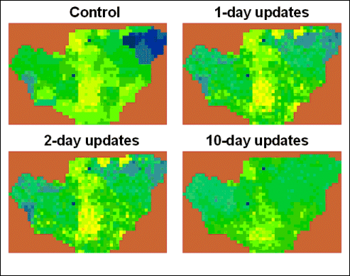
The modeling system has been applied using spatially-distributed data from the Southern Great Plains ’97 (SGP97) field experiment. In the presence of highly inaccurate rainfall input, using remote microwave data via a Kalman filter update scheme drove the model towards the solution obtained in a ‘control’ simulation which used observed rainfall and was shown to produce soil moisture estimates consistent with in situ observations (Fig. 1). As the update frequency was increased, the resulting soil moisture field more closely resembled the control simulation. The following preprint article describes the application of the assimilation model in the SGP97 experiment and shows the relationship between update frequency and the accuracy of modeled soil moisture:
The results of this research have helped quantify the effectiveness of Kalman filter data assimilation in a particular environment and how the period between assimilation times affects model accuracy. Similar research is needed in other locations and times for in order for us to draw more definitive conclusions. We are currently working on improving the data assimilation algorithm by implementing an ensemble Kalman filter; this will eliminate many of the mathematical instabilities and difficulties of the extended Kalman filter.

Acknowledgements:
This research was supported by NASA’s Terrestrial Hydrology Program through grant no. 622-33-36 to Universities Space Research Association and by NASA grant no. NCCW-0084 to Alabama A&M University, Center for Hydrology, Soil Climatology and Remote Sensing.


