


Modeling Tools
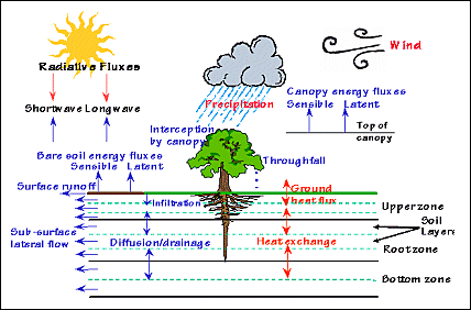 |
| Figure 1: Illustration of the major water and energy fluxes simulated in SHEELS (Simulator for Hydrology and Energy Exchange at the Land Surface) |
The land surface flux-soil moisture model used for much of the hydrology and soil moisture remote sensing research at NSSTC is SHEELS (Simulator for Hydrology and Energy Exchange at the Land Surface). The physics of SHEELS are based on the Biosphere-Atmosphere Transfer Scheme (BATS) of Dickinson et al. (1993). All relevant hydrologic and energy processes are modeled to determine moisture in each soil layer. Fig. 1 (at right) is a schematic showing model inputs and processes. Formulations of variables such as surface energy fluxes and temperatures are similar to those in an earlier version of the model (Smith et al., 1993). The nested three-layer approach of BATS has been converted to a discrete layer configuration in SHEELS, in which the number and depth of layers is flexible. This permits higher vertical resolution near the surface where temperature and moisture gradients are large, and is compatible with remotely sensed moisture data. SHEELS is driven by seven atmospheric variables, which may be spatially distributed or uniform, depending on the scale of the model domain. SHEELS also requires several spatially distributed soil and vegetation properties. A surface routing and streamflow module gives us the capability to simulate a watershed’s hydrologic response to rainfall.
 |
| Figure 2: Example SHEELS output for a two-day period following a significant rain event in the Little Washita River Basin, OK. Output is on an hourly time step; streamflow is estimated at each grid cell and shown here at the river outlet. |
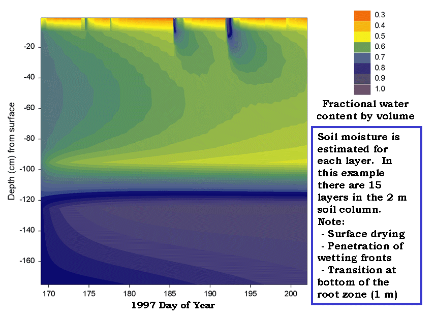 |
| Figure 3: Time-depth cross section of fraction soil water content at a specific location within the Little Washita River Basin. |
The following is a link to a journal article giving more details on SHEELS:
and here is an article discussing the sensitivity of soil moisture estimates to the number and thickness of soil layers:
References cited:
Dickinson, R.E., A. Henderson-Sellers, P.J. Kennedy and F. Giorgi, 1993. Biosphere Atmosphere Transfer Scheme (BATS) version 1e as coupled to the NCAR Community Climate Model. NCAR/TN-387+STR, 72 pp.
Smith, E.A., W.L. Crosson, H.J. Cooper and H.-Y. Weng, 1993. Estimation of surface heat and moisture fluxes over a prairie grassland. Part III: Design of a hybrid physical/remote sensing biosphere model. J. Geophys. Res., 98, 4951-4978.