Other Links
Arenal Region, Costa RicaPayson Sheets, an archeologist from the University of Colorado had a
National Science Foundation grant to excavate prehistoric villages in Costa
Rica. Devastated by ten volcanic eruptions over the past 4000 years, these
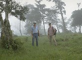
villages were preserved to some extent under layers of ash. As a result of the First Remote Sensing Conference in Archeology in 1984, Tom Sever of NASA joined Sheets's research team to investigate the utility of remote sensing technology in a tropical environment. NASA initiated two series of overflights using a specially equipped Learjet that flew about 1000 ft. high. With the completion of the second series, in the Spring '85, the remote sensing database included:
This was one of the most extensive remote sensing databases created for
archeology to that time.
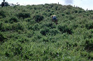
A wandering people lived around Arenal as early as 10,000 BC, finally settling permanently on the nearby lakeshore around 2000 BC The people raised corn and beans and got the rest of their diet from wild crops. The population never grew large enough to require extensive agriculture. This allowed them to survive the eruptions of the Arenal volcano. After an eruption, the people would move 15 or so miles away, and return once crops began to grow again. This resiliency was probably a direct result of the Arenal people's simplicity; a small society in balance with the tropical ecology could bounce back more easily than could a civilization as complex as the Maya. In the end it was likely an epidemic, not an eruption, that doomed the people of Arenal at about the time of the conquistadors. Selected Papers"Remote Sensing in the Arenal Region," In Archaeology, Volcanism, and Remote Sensing in the Arenal Region, Costa Rica, edited by P. Sheets and B. McKee. University of Texas Press, Austin, 1994. "Prehistoric Footpaths in Costa Rica: Remote Sensing and Field Verification," with P. Sheets and B. McKee. In Archaeology, Volcanism, and Remote Sensing in the Arenal Region, Costa Rica, edited by P. Sheets and B. McKee. University of Texas Press, Austin, 1994. "Prehistory and Volcanism in the Arenal Area, Costa Rica," with P. Sheets et al. In Journal of Field Archaeology, Volume 18: Number 4, Winter 1991. "Prehistoric Footpaths in Costa Rica: Transportation and Communication in a Tropical Rainforest," with P. Sheets. In C. Trombold's Ancient Road Networks and Settlement Hierarchies in the New World. Cambridge University Press, Cambridge, 1991. "High Tech Wizardry," In Archaeology, November/December 1988. "Airborne Archeology," World Book Encyclopedia Science Yearbook, 1987. Responsible Official: Dr. James L. Smoot (James.L.Smoot@nasa.gov)
|
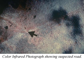 Linear
features were detected in the color infrared photographs. First thought
to be roadways, they seemed to be several feet wide at the surface, upon
excavation, they turned out to be footpaths, the oldest known footpaths.
Using
Linear
features were detected in the color infrared photographs. First thought
to be roadways, they seemed to be several feet wide at the surface, upon
excavation, they turned out to be footpaths, the oldest known footpaths.
Using