Other Links
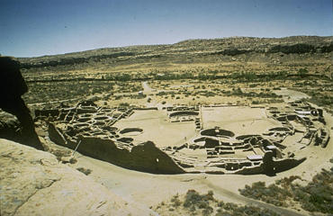
Chaco Canyon, New MexicoThe Chaco Canyon Research Center had done aerial photography and a ground survey. This was the beginning of an archeological database, to which, we proposed to add thermal infrared multispectral data. If our sensors could locate prehistoric features, this would prove that using remote sensing technology could work for archeology.
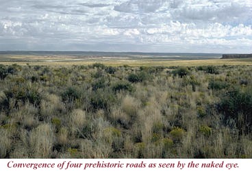
Why were the Chaco roads designed with exacting linearity, which surmounted any topographic obstruction, built to a width of 20 feet or more, and constructed by people who did not even employ beast of burden in their lives? The Chacoan roadway system was an impressive accomplishment that facilitated widespread movement and participation in religious activities. They connected the people along the periphery of the San Juan Basin and beyond to sacred places upon the landscape, to outlier sites, and ultimately to Chaco Canyon itself. |
 The
Thermal Infrared Multispectral Scanner (TIMS) was flown by NASA over Chaco
Canyon for the first time in spring of 1982. TIMS measures temperature differences
near the ground, it has five meter resolution.
The
Thermal Infrared Multispectral Scanner (TIMS) was flown by NASA over Chaco
Canyon for the first time in spring of 1982. TIMS measures temperature differences
near the ground, it has five meter resolution. Selected Papers
"Analysis of Prehistoric Roadways in Chaco Canyon Using Remotely Sensed Digital Data," with D. Wagner. In C. Trombold's (Ed.) Ancient Road Networks and Settlement Hierarchies in the New World. Cambridge University Press, Cambridge, 1991.
"Remote Sensing Applications in Archeological Research: Tracing Prehistoric Human Impact Upon the Environment," Doctoral Dissertation, University of Colorado. University Microfilms, Ann Arbor Michigan, 1990.
Responsible Official: Dr. James L. Smoot (James.L.Smoot@nasa.gov)
Page Author: Tom Sever
Page Curator: Diane Samuelson (diane.samuelson@msfc.nasa.gov)