SPoRT Year In Review: 2020
The nineteenth year of the Short-term Predication Research and Transition (SPoRT) Center was unquestionably the most unique and challenging. Our team has been navigating but embracing the telework environment for nearly 10 months of the year. Despite all the obstacles 2020 threw at our team, we still had an amazing year continuing to leverage satellite remote sensing data to improve short-term forecasting in the operational weather and other associate communities. We wanted to take a minute to share and highlight the successes, achievements, and highlights that our team put together in 2020.
Tropical Meteorology
- SPoRT collaborated with NASA Applied Sciences to plan and execute the Second TROPICS Applications Workshop including national and international participants with the goal to foster interaction between the Science Team and community of end users. A published report and Earth Observer article documented outcomes and recommendations from the workshop.
- Members of the SPoRT Tropical group led a week of daily map discussions (Aug 3-7) for the NOAA Hurricane Research Division (HRD)'s Intensity Forecasting Experiment (IFEX) field campaign.
- Collaboration with STC/JPSS led to development of real-time, experimental NUCAPS product for tropical cyclones to evaluate temperature and moisture anomalies in a storm-relative framework. This product was introduced to the National Hurricane Center.
- An analysis of lightning in Hurricane Dorian (2019) revealed that changes in the size and energy of lightning flashes detected by the Geostationary Lightning Mapper (GLM) could help to predict hurricane intensification.
- SPoRT scientists demonstrated the ability of GPM IMERG rainfall observations to detect cyclical oscillations in the size of a hurricane's rain field throughout the day; developed method to analyze both archived and real-time tropical cyclones using IMERG-Final and the Late/Early products.
- Summer REU efforts by University of Alabama in Huntsville Student Caley Feemster (under guidance from Anita LeRoy of UAH/SPoRT) demonstrated the value of combining passive microwave derived rain rates and wind retrievals over oceans to assess the potential threat to coastal regions from hurricanes and tropical storms. Ms. Feemster developed an RGB combining IMERG rain rates and CYGNSS winds as proxies for the future NASA TROPICS mission data.

These images show an RGB developed by using CYGNSS max daily wind data (in the red channel) and IMERG 24 hr precipitation (in the green and blue channels), gridded to 0.1-degree resolution.
Atmospheric Remote Sensing
- Analysis of fire weather events with Gridded satellite sounding retrievals to demonstrate novel application of NASA observations in support of NOAA Incident Meteorologist training.
- SPoRT expanded real-time Gridded satellite sounding products to real-time processing in web-based displays and other formats to support wide community use as funding awarded by the JPSS PG.
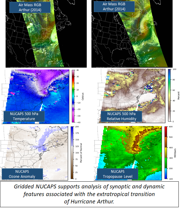
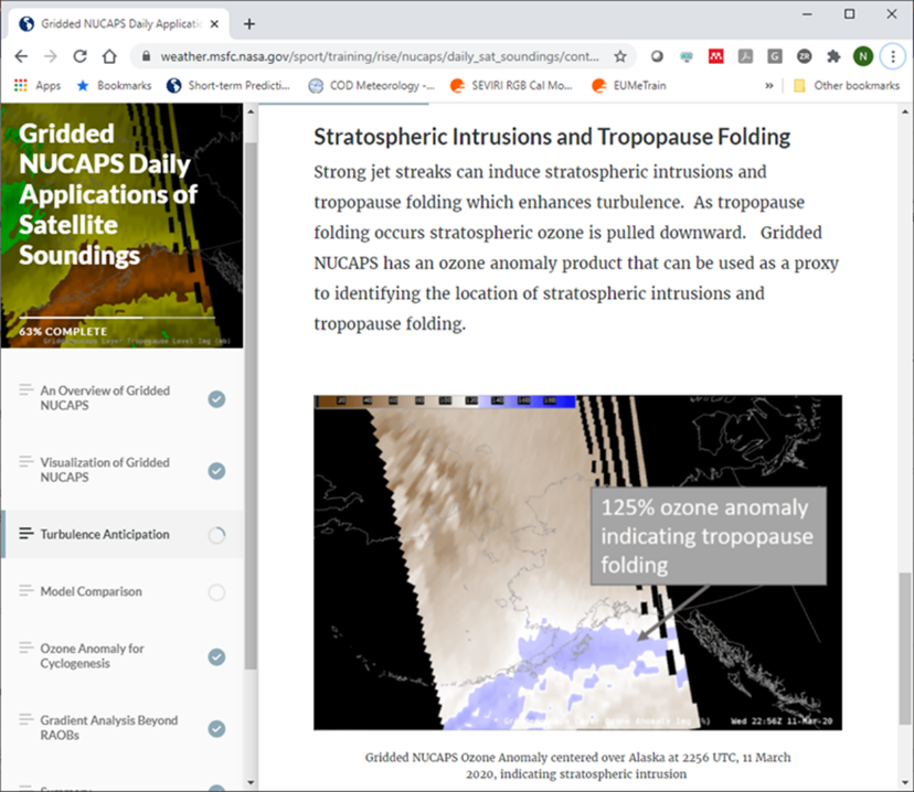
- Gridded satellite sounding level 2 products methodology published in Remote Sensing along with analysis of events ranging from pre-convective monitoring, fire weather, tracking the Saharan Air Layer, and assessment of stratospheric intrusions which impact cyclone intensity.
- Science updates to the JPL NUCAPS-Forecast product and expansion of real-time processing to both S-NPP and NOAA-20 satellites and a real-time web display.
- Proposal awarded by JPL to demonstrate NASA AIRS in the content of the SPoRT-developed satellite sounding applied research that supports operational weather forecasting operations.
- Proposal awarded by the JPSS Proving Ground and Risk Reduction Program “Spatially and Temporally Enhanced NUCAPS Sounding Products for Emerging Applications” to continue SPoRT collaborative efforts with hyperspectral infrared sounders.
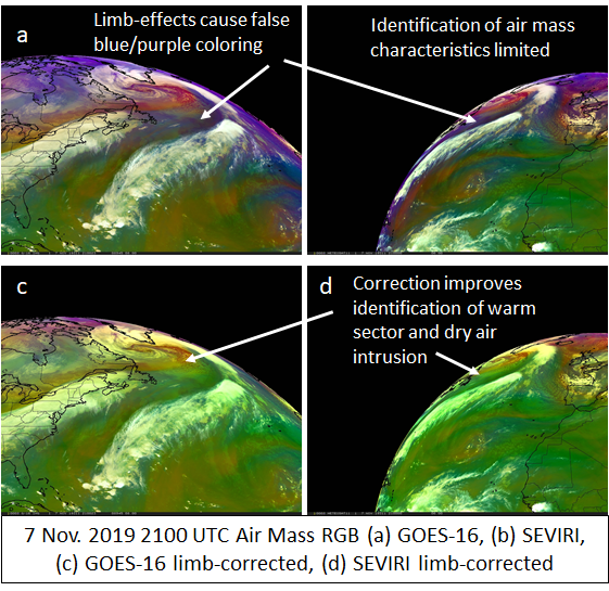
- Proposal awarded by NASA ROSES Earth Science Research from Operational Geostationary Satellite Systems “Development of limb-corrected and intercalibrated multispectral composites from the constellation of geostationary satellites.”
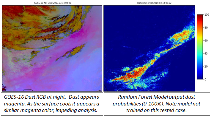
- Expansion of machine learning model capabilities to support detection of nigh-time dust and development of deep learning approaches in collaboration with NASA IMPACT.
- Contributions to the NASA Decadal Survey Aerosols Clouds Convection and Precipitation Mission Study to determine and assess potential applications of this future mission that is now in the pre-formulation stage.
Land Surface Remote Sensing and Modeling
- Led SWOT Early Adopter use of the SWOT mission data simulator by authoring the simulator tutorial and publishing the first SWOT Early Adopter peer-reviewed publication (see publications, DOI 10.1029/2020WR027464). French Space Agency (CNES) scientists coauthored this paper and the agency featured this publication as their September 2020 Image of the Month to illustrate the value of simulated SWOT data in preparing for the mission prelaunch.
- Established an Alaska domain for the NASA Land Information System (LIS), which includes new output products for snow depth, snow water equivalent (SWE), snow melt, and runoff, with a focus on hydrology and wildfire risk. We are providing this output to the Alaska-Pacific River Forecast Center and Alaska WFOs, and to wildfire researchers and managers at the Alaska Interagency Coordination Center.
- Provided soil moisture forecasts in Africa for purposes of locust swarm monitoring and mitigation. 15-day LIS forecasts of soil moisture, forced by Global Forecast System (GFS) output, were established for an existing East Africa domain and a new North Africa domain. These model simulations are done in partnership with SERVIR and are provided to the UN Food and Agriculture Organization.
- Implemented a forecast capability for the SPoRT-LIS product, initially using GFS model forecasts out to 10+ days. In conjunction with an application of SPoRT-LIS to tropical cyclone extreme rainfall events, demonstrated a prototype of SPoRT-LIS forecasts for Tropical Storm Imelda (2019) over southeastern Texas in a manuscript accepted for publication in the NWA Journal of Operational Meteorology.
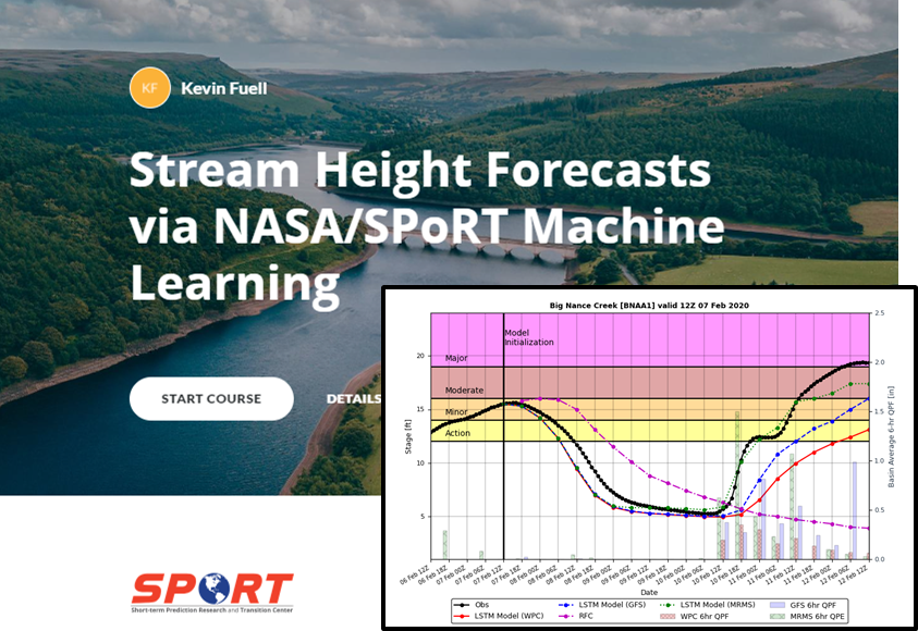
- Developed a deep learning model to produce 7-day flood forecasts on over 50 rivers and streams across the Eastern U.S. This output is currently provided to four NWS WFOs and two River Forecast Centers.

Mean bias and root-mean-square bias statistics for SPoRT LSTM stream height forecasts of Big Wills Creek.
Lightning & Hazardous Weather
- Examined the sensitivity of the WRF model Lightning Forecasting Algorithm (developed under GOES-R PG funds) to varying planetary boundary layer and microphysics parameterization schemes in an application of SERVIR's HIWAT ensemble forecasting system over south Asia. Published manuscript in August issue of Weather and Forecasting.
- Developed and tested a machine learning method to predict lightning 5 to 15 minutes in advance of its occurrence to improve lightning safety.
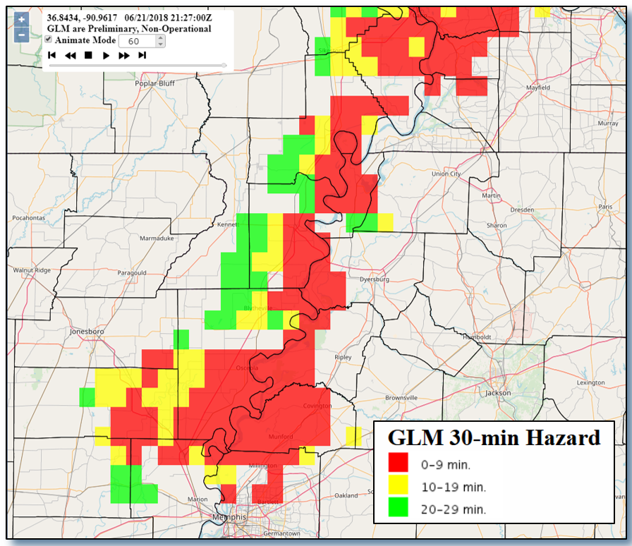
Example of 30 minute lightning hazard product in western Tennessee (21 June 2018)
- As a funded Competed NASA Disaster's effort with NASA Langley, assess the damage from the 9 billion-dollar Iowa/Illinois Derecho from August, and the 1.2 billion-dollar Calgary hailstorm from June.
- Continue to work with Goddard and the National Severe Storms Laboratory (NSSL) to implement NSSL electrification parameterization into the NASA Unified-WRF model to understand the physical, dynamical, and electrical drivers within hailstorm formation and maintenance.
- Publication in Weather and Forecasting "Characterization of Snowfall Rates, Totals, and Snow-to-Liquid Ratios in Electrified Snowfall Events Identified by the Geostationary Lightning Mapper” which characterizes thundersnow events from a GLM perspective, finding TSSN occurred where SLR of 8:1 to 10:1 and associated with ice particles with some degree of riming. In addition, the study added that TSSN does not occur in the highest snowfall rates but within a mean snowfall rate of 1.73 cm/hr.
- NASA FINNEST proposal awarded to SPoRT doctoral student Sebastian Harkema “Microphysical Examination of Electrified Snowfall Events Using GOES ABI/GLM and NU-WRF”
Air Quality & Human Health
- Development of a robust TEMPO Early Adopters Program with many new users from air quality and health organizations. Creation of new synthetic TEMPO data products to enhance engagement with early adopters and fully prepare users for the suite of operational TEMPO products.
- Analysis of trace gas products from TROPOMI during the COVID-19 pandemic highlighted the new capabilities of observing rapid changes in pollution from space due to abrupt slowdowns in human activity. Demonstrated how implementation of Clean Air Act policies could govern future air pollution.
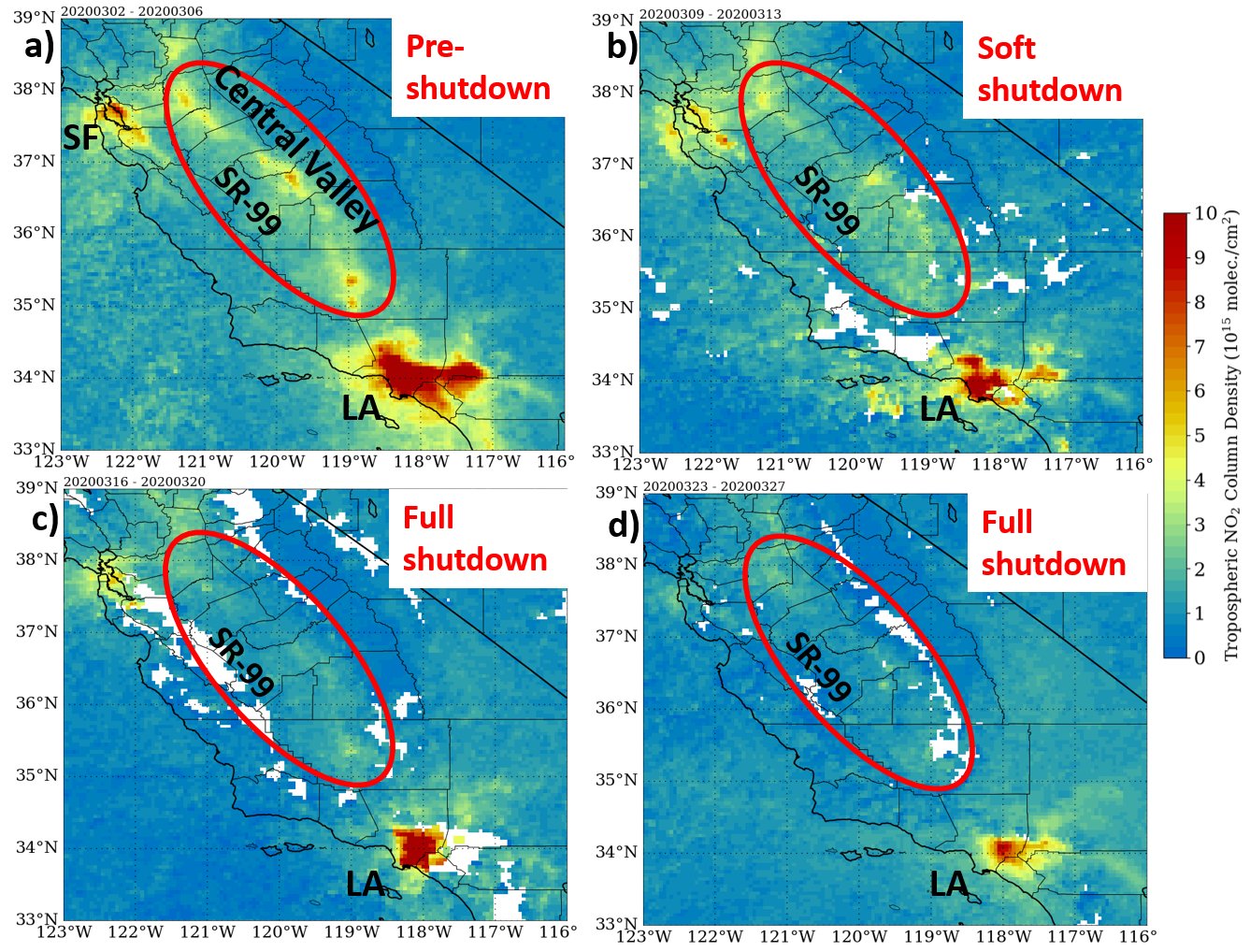
Figures a) Gridded 0.05 x 0.05° NO2map from TROPOMI Offline (OFFL) L2 retrievals during 2-6 March 2020 (pre-shutdown) over California. b-d) Same as a), except valid for b) 9-13 March during soft shutdown measures, c) 16-20 March when “shelter in place” orders were announced, d) full period of “shelter in place” orders during 23-27 March. Panel d) generated using near real-time (NRT) product due to 7-10 day lag of OFFL product.
- Development of value-added, near real-time air quality products from multi-satellite observations and high-resolution model forecasts to advance air quality monitoring capabilities in the SERVIR Hindu Kush Himalayan (HKH) region of South Asia. Formulation of a new aerosol optical depth (AOD) retrieval algorithm over the HKH region using geostationary satellite observations, in addition to multi-channel Red-Green-Blue (RGB) products for dust and nighttime microphysics (fog detection); adapting SPoRT methodologies to the HKH region.
- Preparation for an innovative cross-cutting study awarded as a SMAP Science Team project with the goal of evaluating the impacts of soil NOx emissions on air quality using synergistic trace gas and soil moisture products from TROPOMI, TEMPO, and SMAP observations.
Engagement, Training, and Assessments
- Development of online applications training for NUCAPS data related to Fire Weather, Turbulence and Cyclogenesis Analysis, NWP Complement and Comparison, and Upper Air Gradient/Fronts Identification:
- A training course for understanding the use of passive microwave (PMW) instruments and data was developed to support a summer student research and to help other in-house scientists sharpen their knowledge of PMW and use it effectively in their research.
- Assessment initiated for Gridded NUCAPS products in operations by local NWS offices and National Centers; focus on applications of Gridded NUCAPS and efficiency of data display for operational utilization.
- Support of GOES and JPSS Programs: Level-2 Applications Training (Quick Guides and Quick Briefs):
- Completion of GOES ABI training for RGB-imagery products and integration to user's system.
- Creation of new training for JPSS and NASA-related instruments on passive microwave channels.
- Engagement of Alaska users with NASA LIS output:
- Creation of LIS 'Starter Package' training for support of user application and assessment.
- Training for use of NASA Limb-Correction Air Mass RGB in operations, derived from previous work done by SPoRT NPP Dr. Nicholas Elmer.
- Engagement of users to identify solution for stream height forecast needs beyond 48 hours via Machine Learning technics that utilize the NASA LIS capabilities; Development of training for the resulting product; and Assessment of the product with hydrology users in the Southeast. All possible due to collaboration with NWS Applications Integration Meteorologist (AIM) at co-located office.
- Proposal awarded by the JPSS Proving Ground and Risk Reduction program “Micro-lesson Training Series for JPSS Snow, Ice, and Soil Moisture Products.”
Publications
- Bell, J.R., E. Gebremichael, A. Molthan, L.A. Schultz, F.J. Meyer, C.R. Hain, S. Shrestha and K. C. Payne, 2020: Complementing Optical Remote Sensing with Synthetic Aperture Radar Observations of Hail Damage Swaths to Agricultural Crops in the Central United States. J. Appl. Meteor. Clim, 59(4), 665-685. https://doi.org/10.1175/JAMC-D-19-0124.1.
- Berndt, E.; Smith, N.; Burks, J., White, K., Esmaili, R., Kuciauskas, A., Duran, E., Allen, R., LaFontaine, F., Szkodzinski, J., 2020: Gridded Satellite Sounding Retrievals in Operational Weather Forecasting: Product Description and Emerging Applications. Remote Sens. 12, 3311. https://doi.org/10.3390/rs12203311.
- Berndt, E., J. Dunion, E. Duran, P. Duran, W. Blackwell, S. Braun, and D. Green, 2020: Second Time-Resolved Observations of Precipitation Structure and Storm Intensity with a Constellation of SmallSats (TROPICS) Mission Applications Workshop Summary Report., In Press.
- Case, J. L., L. Wood, J. Blaes, K. D. White, C. R. Hain, and C. J. Schultz, 2020: Soil moisture responses associated with significant tropical cyclone rainfall events. J. Oper. Meteor., In Press.
- Cawse-Nicholson, K., A. Braverman, E. Kang, M. Li, M. Johnson, G. Halverson, M.C. Anderson, C.R. Hain, M. Gunson and S. Hook, 2020: Sensitivity and uncertainty quantification for ECOSTRESS evapotranspiration algorithm-DisALEXI. Int. J. of Appl. Earth Obs. Geoinfo, 89, 1202088.
- Elmer, N. J., C. R. Hain, F. Hossain, D. Desroches, C. Pottier, 2020: Generating proxy SWOT water surface elevations using WRF-Hydro and the CNES SWOT Hydrology Simulator, Water Resources Research, 56, e2020WR027464, https://doi.org/10.1029/2020WR027464.
- Elmer, N. J., C. Hain, J. McCreight, and D. Gochis, 2020:, SWOT Applications for WRF-Hydro Modeling in Alaska, in Proceedings of the IEEE, in press.
- Esmaili, R., N. Smith, E. Berndt, B. Kahn, K. Write, C. Barnet, W. Sjoberg, and M. Goldbert, 2020: Adapting Satellite Soundings for Operational Forecasting within the Hazardous Weather Testbed, Remote Sens., 12(5), 886-893. https://doi.org/10.3390/rs12050886.
- Grasso, L., Bikos, D., Torres, J., Dostalek, J. F., Wu, T.-C., Forsythe, J., Cronk, H. Q., Seaman, C. J., Miller, S. D., Berndt, E., Weinman, H. G., and Kasper, K. B, 2020: Satellite Imagery and Products of the 16–17 February 2020 Saharan Air Layer Dust Event over the Eastern Atlantic: Impacts of Water Vapor on Dust Detection and Morphology, Atmos. Meas. Tech. Discuss, in review. https://doi.org/10.5194/amt-2020-354.
- Harkema, S., E. Berndt, and C. Schultz, 2020: Characterization of Snowfall Rates, Totals, and Snow-to-Liquid Ratios in Electrified Snowfall Events Identified by the Geostationary Lightning Mapper. Wea. Forecasting, 35, 673-689. https://doi.org/10.1175/WAF-D-19-0126.1.
- Hossain, F., N. Elmer, M. Srinivasan, and A. Andral (2020), Accelerating Applications for Planned NASA Satellite Missions: A New Paradigm of Virtual Hackathons during Pandemic and Post-Pandemic Era, Bull. Amer. Meteor. Soc. https://doi.org/10.1175/BAMS-D-20-0167.1.
- Hossain, F., M. Bonnema, M. Srinivasan, E. Beighley, A. Andral, B. Doorn, I. Jayaluxmi, S. Jayasinghe, Y. Kaheil, B. Fatima, N. Elmer, L. Fenoglio, J. Bales, F. Lefevre, S. Legrand, D. Brunel, and P.-Y. Le Traon, 2020: The Early Adopter Program for the Surface Water Ocean Topography Satellite Mission: Lessons Learned in Building User Engagement during the Pre-launch Era, Bull. Amer. Meteor. Soc., 101, E259–E264, https://doi.org/10.1175/BAMS-D-19-0235.1.
- Leroy, A., E. Berndt, A. Molthan, B. Zavodsky, M. Smith, F. LaFontaine, K. McGrath, and K. Fuell, 2020: Operational Applications of Global Precipitation Measurement Observations. In Levizzani et al. (Eds.) Satellite Precipitation Measurement Vol. 2(919-940) https://link.springer.com/chapter/10.1007/978-3-030-35798-6_23.
- McCaul, E., G. Priftis, J. Case, T. Chronis, P. Gatlin, and S. Goodman, 2020: Sensitivities of the WRF Lightning Forecasting Algorithm (LFA) to parameterized microphysics and boundary layer schemes. Wea. Forecasting, Wea. Forecasting, 35(4), 1545-1560. https://doi.org/10.1175/WAF-D-19-0101.1.
- Ruppert, J. H., A. A. Wing, X. Tang, and E. L. Duran, 2020: The Critical Role of Cloud-Infrared Radiation Feedback in Tropical Cyclones, Proc Nat. Acad. Sci., 202013584; https://doi.org/10.1073/pnas.2013584117.
- Schultz, C. J., V. P. Andrews, K. D. Genareau, and A. R. Naeger, 2020: Observations of Lightning in Relation to Transitions in Volcanic Activity During the 3 June 2018 Fuego Eruption. Scientific Reports, https://www.nature.com/articles/s41598-020-74576-x.