


Experiments
 Previous large-scale field experiments over the Southern Great Plains (SGP ’97 and ‘99) of Oklahoma have been very successful at addressing a broad range of science and instrument questions. The data have been used in studies that went well beyond algorithm research. Soil Moisture Experiments in 2002 (SMEX02) continued this progress with emphasis on validation of brightness temperatures and soil moisture products from the Advanced Microwave Scanning Radiometer (AMSR-E), extension of instrument observations and algorithms to more challenging vegetation conditions, evaluation of new instrument technologies for soil moisture remote sensing, and to understand land-atmosphere interactions.
The Passive and Active L and S band microwave instrument (PALS) and the Polarimetric Scanning Radiometer (PSR) were deployed on aircraft to map brightness temperatures at two spatial scales (Figure 1 above). Aircraft flights were coordinated to coincide as well as possible with satellite radiometer measurements. Ground sampling teams produced a wealth of data at field, watershed and regional scale for validation efforts. The small-scale intensive sampling domain of about 10 x 20 km was centered over the Walnut Creek watershed. Corn and soybean were the dominant land cover of the study area. Thirty-one fields within this domain were sampled daily with four samples for gravimetric water content and 14 samples for volumetric water content using an impedence probe. The small-scale domain was nested within a large-scale regional domain measuring about 50 x 100 km.
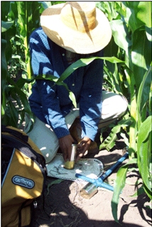 Investigators from the Global Hydrology and Climate Center supported field sampling during SMEX02, which was conducted in central Iowa from June 24 - July 12, 2002. In addition, we deployed and operated four automated stations to provide continuous measurements of profile soil moisture to a depth of 60 cm. On each of the fields we sampled, the near-surface (0-6 cm) soil moisture profile was measured using a standard soil core sampler. For our purpose of obtaining high-resolution surface moisture profiles, the samplers were filled with 1 cm cylinders that allowed the core to be sliced (Figure on right). Six sliced cores were obtained daily ( 9:00-12:00 LDT) from four locations each at four fields during the experiment (Figure on left).
 We compare soil moisture retrieved with an inverse algorithm with observations of mean moisture in the 0-6 cm soil layer. A significant discrepancy is noted between the retrieved and observed moisture. Under relatively dry conditions, the observed moisture overestimates retrieved moisture by about 0.05 volumetric water content and underestimates retrieved moisture by about 0.10 volumetric water content under relatively wet conditions (Figure 3). This discrepancy exists in part because retrieved moisture is a depth-dependent effective value whereas observed moisture is a mean value. We characterized emission as a function of depth for each observation and used them as weighting functions to convert the observed mean moisture to observed effective moisture. This removed nearly one-half of the discrepancy noted between retrieved effective moisture and observed mean near-surface moisture. This result has important implications in remote sensing validation studies.
We developed an optimal deconvolution (ODC) technique to estimate microwave brightness temperatures of agricultural fields using microwave radiometer observations with significant oversampling. The technique was applied to airborne measurements taken by the PALS sensor during SMEX02. Conventional spatial interpolation methods produce smooth spatial data fields of brightness temperatures, which may reduce the contrast in brightness temperatures between adjacent landcover types. Instead, we mathematically de-convolve the observations into brightness temperature at the field scale using the sensor antenna response function. The result is more accurate spatial representation of field-scale brightness temperatures, which may in turn lead to more accurate soil moisture retrieval.

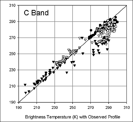
Comparison between brightness temperatures (L and C band) computed with
observed moisture profiles and with mean near-surface moisture for four study sites.
Acknowledgements:
This research was supported by NASA through grant no. 291-07-75-90 to Universities Space Research Association and grant no. NCCW-0084 to Alabama A&M University, Center for Hydrology, Soil Climatology and Remote Sensing.